 Microsoft’s search engine, Bing, Funnyordie and Coachella 2010 worked together the weekend of April 16-18, 2010 to engage with music fans from all over the world using geolocation technology.
Everybody knows Coachella is one of the biggest live music events in North America, but there are also millions of fans following the festival online through initiatives such as Bing Twitter Maps.
What is Bing Twitter Maps?
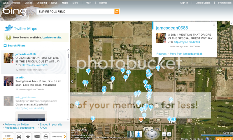
Bing Maps has a a Silverlight interface, its own version of Google Map’s Street View (called Street Side), Photosynth and Twitter integration–it even has an app store. Bing Maps Twitter’s geolocation API to map out tweets that deal with topics relating to your neighborhood. Bing Twitter Maps places each tweet on the map, along with the Twitterer’s username and avatar. You can drill down based on topics or locations as well.
Here’s a sample screenshot:

How is Coachella 2010 using Bing Twitter Maps?
Bing Twitter Maps, which utilizes the Twitter geolocation API to visualize tweets onto Bing Maps, has partnered with Funny or Die, because of their large Twitter following and highly engaged audience.
Leveraging @funnyordie’s 1.4 million Twitter followers, Bing wanted to interact with concertgoers and music fans throughout the three-day event in Indigo, California.
Funny or Die will be tweeting from Coachella a series of geotagged tweets with Bing Twitter maps, including:
- Live scavenger hunt asking followers to snap photos of items from secret locations, only revealed via Bing Twitter Maps
- Offering free water bottles to first followers to arrive at secret locations
- Free “Dick Towels” – from the popular episode from It’s Always Sunny in Philadelphia – to those who could locate them using Bing Twitter Maps
Here’s a sample of screen shot of what’s going on as of Friday April 16th (click for larger version):
You can check out all the shenanigans by visiting www.bit.ly/CoachellaMap


One thought on “Coachella 2010 Using Bing Twitter Maps”
Comments are closed.